High Resolution 3-D Structural Tomography of Vp, Vs and Vp/Vs beneath Agung Volcano, Bali, Using the ITB Seismograph Network
Mount Agung is one of the active volcanoes in Indonesia, located on the island of Bali. After more than 50 years, Mount Agung experienced another explosive eruption on November 21 2017. The last major eruption of Agung occurred in 1963 with VEI 5, this eruption was one of the largest eruptions in the 20th century. The 1963 eruption is thought to have influenced the global climate. Therefore, it is very important to study the seismic structure below the surface of this mountain to support efforts to mitigate volcanic eruptions. In our research, we collaborated with the Center for Volcanology and Geological Hazard Mitigation (PVMBG), PEER USAID and several seismographers from the Australian National University (ANU) to install 25 temporary seismographs around Mount Agung and Mount Batur, Bali for the time period December 2018 to September 2019 along with 10 pre-existing PVMBG permanent seismographs. The aim of this research is to understand the volcanic-tectonic (VT) earthquake source mechanism and the magmatic plumbing system model of Mount Agung.
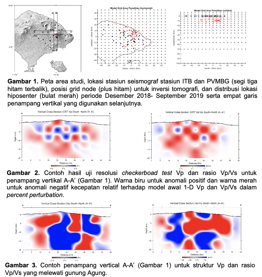
Figure 1. Map of the study area, location of ITB and PVMBG seismograph stations (inverted black triangles), grid node positions (black plus) for tomographic inversion, and distribution of hypocenter locations (red circles) for the period December 2018-September 2019 and four cross-sectional lines vertical is used next.
Figure 2. Example of checkerboard test results Vp resolution and Vp/Vs ratio for vertical section A-A’ (Figure 1). Blue color for positive anomalies and red color for negative anomalies of velocity relative to the initial 1-D model Vp and Vp/Vs in percent perturbation.
Figure 3. Example of vertical cross section A-A’ (Figure 1) for the Vp structure and Vp/Vs ratio passing through Mount Agung.
This research was supported by the 2020 ITB KK-A Research Grant, 2020 RISTEK/BRIN Master’s Thesis Research, seismograph installation activities were supported by PEER USAID 2019-2021, several seismographs were supported by the Australian National University. We would like to thank PVMBG for permission to install the equipment and use the volcanic-tectonic earthquake waveform data from Mount Agung, Bali.
Some of the outputs resulting from this research are:
Ardianto, A,. Nugraha, A. D., Afif, H., Syahbana, D. K., Sahara, D. P., Zulfakriza, Z., Widiyantoro, S., Priyono, A., Rosalia, S., Saepuloh, A., Kasbani, K., Muttaqy, F ., Puput, P. R., Imam, C. P., Martanto, M., Imaging the subsurface structure of Mount Agung in Bali (Indonesia) using volcano-tectonic (VT) earthquake tomography, Frontiers in Earth Science, 2020, Under Review. (Q1 Scimago).
Gunawan, M. T., Kusnandar, R., Supendi, P., Nugraha, A. D., Puspito, N. T., Daryono, Sahara, D. P., Zulfakriza., Analysis of swarm earthquakes around Mt. Agung Bali, Indonesia prior to November 2017 eruption using regional BMKG network, Geoscience Letters, 2020, 7:14, https://doi.org/10.1186/s40562-020-00163-7. (Q1, Scimago).
Rahsetyo, P. P., Sahara, D. P., Nugraha, A. D., Zulfakriza, Z., Syahbana, D. K., Martanto, M., Afif, H., Signal Characteristics of Volcanic Earthquakes on Agung Volcano in November 2017, The 45th Annual Scientific Meeting of Himpunan Indonesian Geophysicist, Surabaya, 12-15 October 2020.
Zahwa, F., Nugraha, A. D., Rosalia, S., Sahara, D. P., Zulfakriza, Z., Ardianto, A., Widiyantoro, S., Priyono, A., Kusumawati, D., Prabowo, B. S., Husni, Y. M. , Syahbana, D. K., Martanto, M., Afif, H. D., Q-Tomography Beneath Agung Volcano, Bali, Indonesia, Using Local Seismic Network: A Prelminary Result., American Geophysical Union Fall Meeting, San-Francisco, December, 2020, Submitted